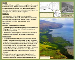
Sarah and Lily Jenkins of Molokai High School used GIS software to investigate whether Red Mangrove will reach and establish itself on Molokai’s fringing reef and what the resulting socio-economic and ecological impacts would be, if so. 

mangrove pix

March of the Molokai Mangrove ’15 3.20.15

Sarah and Lily will be competing in the Intel International Science and Engineering Fair (ISEF) in May after winning awards at both the 2015 Maui Schools Science & Engineering Fair and the 2015 Hawai’i State Science and Engineering Fair (HSSEF).  

Congratulations Sarah and Lily for making Moloka`i, Maui County and the entire state of Hawai`i so proud!

“Thank you again for investing in my sister Lily and I to attend the MEDB GIS workshop a few months ago. Please also send our mahalos to Charlie Fitzpatrick for providing us with the ArcGIS 10.2.2 software and professional development. Our success at the Hawaii State Science and Engineering Fair would not have been possible without the support of MEDB-WIT and Esri (Charlie Fitzpatrick and Craig Clouet). - Sarah Jenkins, Moloka`i High School Senior.

Charlie Fitzpatrick, Esri Schools Program Manager, would like educators to be aware of the following GIS educator press resource:

Getting to Know Web GIS

http://esripress.esri.com/display/index.cfm?fuseaction=display&websiteID=283

Also, remember that Esri allows educators to request 3 free books every 4 months.

 Of the 10 chapters in the book, at least the first 6 are valuable for many educators. As part of this, you will see the integration of ArcGIS Desktop with ArcGIS Online. There are already small cosmetic differences or functional gaps visible, and will be more as the months pass and the ArcGIS Online software continues its steady evolution, but the fundamentals of the book are sound and stable: maps and apps, for various purposes, with various tools, built in various ways, following best practices, can have huge impact in this connected world.


Mahalo, Charlie, for the great tips!

October 14-16, Island Futures GIS & Planning Conference.
Check out the webpage for more details

http://www.islandfutureshawaii.org/

ArcGIS Online Photostory Link

The goal of this project was to try and map the deer population, to make a public map to assist the local hunters in their efforts to control the invasive deer population on Maui.


We believe local farms and resorts can benefit from this project. If the deer population becomes more controlled, there will be less property damage and crop damage. Repair costs will diminish giving them the chance to spend more money on making their business better.
Throughout this project, we had two main contacts. This included Kanalu Sproat, Maui Axis Deer Coordinator, and Kenneth Yamamura, Maui County Agricultural Specialist. We had gotten information from Kanalu that helped us put information on this map.


We encountered difficulties during this project including trying to get visual confirmation of the deer in areas where the deer were reported.


During this project, our knowledge in GPS technology and ArcGIS/Esri became more advanced. Our project is still ongoing and we will continue to update the map with any information we may get.

The State of Hawaii - Office of Planning has an abundance of Hawaii GIS data which has been conveniently grouped into the following categories:

Agriculture and Farming

Biologic and Ecologic

Administrative and Political Boundaries

Atmospheric and Climatic

(Image from the Wind Energy Resource section)

Business and Economy

Elevation and Derived Products

Environmental

Geologic and Geophysical

Human Health and Safety

(Image from the Lava Flow Hazard Zones section)

Imagery and Basemaps

Military and Intelligence

Inland Water Resources

Locations and Geodetic Networks

Oceans and Estuaries

Cadastral and Land Descriptions

Cultural and Demographic

Facilities and Structures

Transportation Networks

Utilities Networks